Near Lawton in southwest Oklahoma is the unplowed and untouched WM Wildlife Refuge (60,000 acres), as well as Fort Sill--the latter being the largest artillery training school in the country, and comprising a large chunk of the mountains as a firing range (alas). More on the fort later.
 |
| One range of many set against the undisturbed prairie |
Within the refuge are many lakes, I mean dammed creeks. Below is Lost Lake, where for a brief time I did indeed feel its name.
 | ||||||||||||||
| The diverse vistas--water, prairie, woods, rocks |


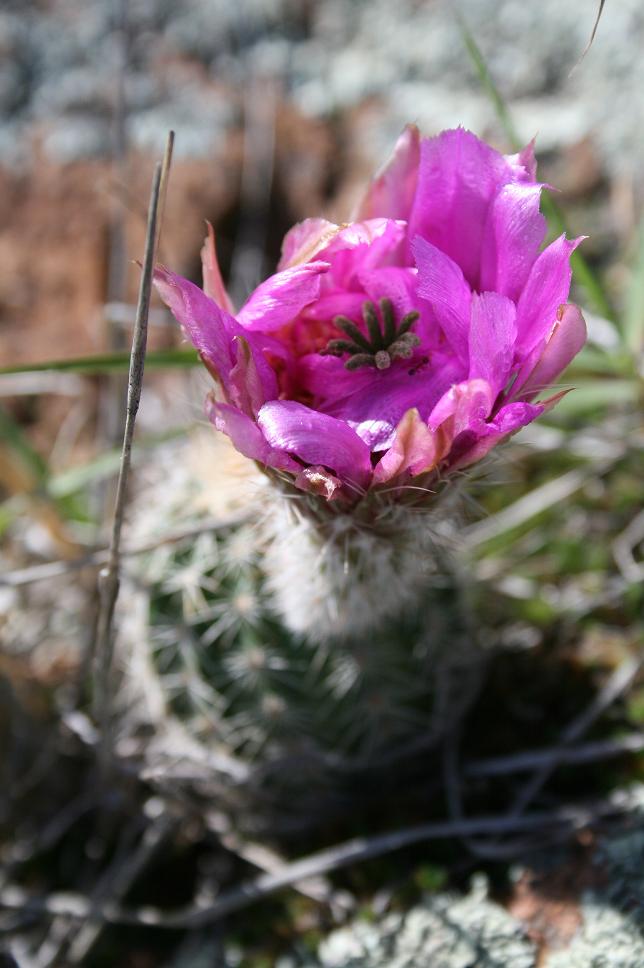 |
| Cactus bloom |
Central Oklahoma used to be awash in a north / south strip of post oaks and blackjack oaks called cross timbers, which are short, thick-trunked, wind-stripped trees that were virtually impassable for wagons. Below is a small remnant in the WMWR.

We also took the winding road up Mt. Scott, the second highest peak in the range. I was absolutely terrified driving the car, thinking that at any moment I'd suddenly go insane and rev the car off the road and make us plummet to our deaths (I hate 6' ladders, mind you). My wife scoffed. But once our ears popped and we made it to the top, she was scared to climb the rocks and peer down, whereas I felt like a little boy, giddy as I hopped large boulders in a single bound. I'm a prairie boy, so it was a whole new plain of existence (get it? huh?).

The Wichitas are over 500 million years old, the oldest mountain range in the U.S. In the late 1800s gold was reported, and many soldiers deserted from nearby Fort Sill to strike it rich, but no gold was ever found.
 |
| That's a road way down there |
 |
| Wind farm in the distance |

We met a drawly man at the top with a troop of teenaged boys, and he pointed out what must have been tens of thousands of lady bugs. They were on trees, rocks, leaves.... Why were they there? He gathered some to take home to his garden (he also later told us how he recently went on a junk-hunting excursion when a local lake was drained, and about all the neat bottles he found).
One of the few black-tailed prairie dog colonies is also in the refuge. There's one in Lawton, too, after the townsfolk gave up eradicating them from their parks. It seems to me the plow did a good enough job of that in the Plains.
 |
| Mom watching the kids? |
 | |
| Would love to know what ground cover they were eating. |

 | |
| I want these flowers carpeting my lawn. |
I had to literally pull my wife away from the prairie dogs. I see giant rats, she sees cute furry squirrel things to play with and kiss. But it was neat how, driving through the refuge, you suddenly roll right through their town. They scamper across the road, walk right up to you, call to one another from hole to hole, dart in and out of holes, peek their heads out like womp-a-moles at the arcade....
 |
| The last bison? |
The refuge has a small bison herd, started from a NYC zoo contingent, as wells as re-introduced elk, deer, and longhorn cattle that look more menacing than the bison even while they're lounging.

Then there's dung beetles hard at work rolling stuff around backwards:

And after days of my wife pointing out darting scissortail flycatchers to me, I finally got a picture:


Northwest of the range is Rainy Mountain, a Kiowa sacred site that author N. Scott Momaday writes so eloquently about in his book The Way to Rainy Mountain. You might have noticed me quoting him in three previous posts the last two weeks as an invocation--a sort of watching over of the trip.

"Loneliness is an aspect of the land. All things in the plain are isolate; there is no confusion of objects in the eye, but one hill or one tree or one man. To look upon that landscape in the early morning, with the sun at your back, is to lose the sense of proportion. Your imagination comes to life, and this, you think, is where Creation began." -- Momaday
North of Lawton, and extending all along the southern edge of the mountains, is Fort Sill, established in 1869 shortly after the massacre of Black Kettle's Cheyenne band up the Washita River (that's the next blog post). It is the only remaining fort from the southern Indian Wars and the Red River War still in use today--and in lots of use. We drove by about 100 cadets training in full gear near a patch of woods. Machine guns. Camo. Trucks. It was strange how at the main gate the guards simply scanned our driver's licenses, then waved us through, along with hundreds of other cars. The guard who greeted us had a hook for one hand.
Ft. Sill is the resting place of Geronimo and several of his wives and children. Why do we yell "Geronimo" when we make physical leaps of faith? Because we're culturally ignorant. No, (yes) it's actually after a presumed leap Geronimo made off the nearby Medicine Bluffs on horseback while trying to escape, but no such thing ever happened. Paratroopers stationed at the fort used his name while jumping from planes.

Quanah Parker is also buried at Ft. Sill. However, unlike Geronimo, his grave is at the center of the fort, not several miles west across I-44. Parker was the last of the Comanche chiefs to surrender--his mother was a captured white woman who was adopted into the tribe. Parker went on hunting trips with Theodore Roosevelt, and was one of the founders of the Native American Church, a blending of the peyote religion and Christianity.

And it is fitting, with all this Native American history buried at the fort--and the similar (ab)use of the rare ecosystems of the Wichitas--that our last image be of this:

My grandfather would have driven something similar--a mobile howitzer--in the Korean War. There were many impressive track and field artillery pieces dating back to WWI on the grounds, and of course, original buildings from the 1800s, including the guardhouse where Geronimo was held.
Oh, I can't end there. Here's something my wife pointed out:

I wonder how he managed during that night's baseball-sized hail? We were fortunate to JUST BARELY avoid hail and tornados the entire trip. When we left Oklahoma to return home, the interstate we drove that morning near El Reno had a tornado cross right over it in the afternoon, killing several people nearby.
Next and last stop, my family's 1894 homestead, and the Washita Battlefield where Custer began the myth behind the man. And, perhaps, where Oklahoma truly ends and begins.
(For part 1 of our trip to Bartlesville, the Tall Grass Prairie Preserve, and Oklahoma City, link here.)
10 comments:
Mountains in Oklahoma, who knew? You of course. I am with you on the lure of the mountains, though driving in them does not bother me, riding with someone else driving does. Being a flatlander, I love my trips to the mountains. I am enjoying your trip and look forward to the next post.
Is a Native American Church still active?
Les--Is 2400 feet a mountain? I've never been to a mountain before that I can recall, though I've seen them in the distance, as in Seattle.
EE--I'm sure there are many practicing in the NA Church still. It's like saying someone is catholic or baptist--it isn't a place, per se.
Benjamin, I shared this post with my husband~he grew up in OK and will love your prose and photos. I did, gail
Thanks Gail! I can't believe more people haven't stopped by to read these posts. I guess I should just post pretty flowers and call it a day. Let me know what your husband thinks? Esp after the third post coming up soon.
He loved it Benjamin. He said in an email back to me: "...caught the look, the feel, and the attraction of the area. although i think only okies can truly appreciate the understated beauty of the rolling plains, the black oaks, the hundreds of different types of grasses, low mountains (to some the high hills) and the wind. the every present glorious wind. " gail
NO, DON'T stick with 'just pretty flowers' I have been caught up in your writing and your story. Just came back to read the newer comments!
Gail--Thanks, Gail's husband! I never knew Oklahoma until recently, and maybe still don't. There's a reason it's the most ecologically diverse state in the U.S.--the range of environments is mind boggling, and surprising, given the terraforming that went on there.
EE--Ok, no more pretty flowers for a while. Plenty of those post around the blogosphere already (too many?).
wow, your pictures are quite beautiful also, i really enjoy all the info you include along with them. I shall be checking back here quite often:)
Howdy Benjamin,
If I seem to recall correctly, a mountain is officially 2,000' in elevation above sea level or higher.
As for the wildflowers the prairie dogs were munching on, appears to be Basin Sneezeweed (Helenium amarum var. badium)
Enjoyed your post and pics! That is a nice place - need to visit there again.
Post a Comment